When we study the geography of India, we are told that the northern plains are a very important part of our country. That is totally right. Another name for The Northern plains is also the Indo-Gangetic Plains. This region has been named after the two major rivers – Indus and Ganga. The stretch of this plain is approximately 2.5 square kilometers. The plains are very fertile providing ample space for irrigation practices.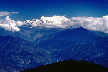
History Of Northern Plains
This region is popularly known for the Indus Valley Civilization. The fertile and flat land that is perfectly suitable for inhabitants has caused various empires like the Mughals, Mauryas, and Gupta Empires to rise.
Location
These plains lie south of Shivaliks and cover a major part of northern and eastern India. In the north of these plains, lie the Himalayas. The plains are separated from the Shivaliks by the Himalaya Frontal Fault (HFF). on the south of the plain lies the Chota Nagpur Plateau. On the west lies the Iranian Plateau and on the east are the Purvanchal Hills.
Formation
When the Himalayas got uplifted, there was a foredeep basin formed because the Indian Peninsula’s northern part subsided. This basin was filled up by the sediments that were brought down from the Himalayas by the rivers. The sediments were rich in alluvial and when they kept on depositing, it led to the formation of the fertile land in the north of India called the Northern Plains.
Characteristics
The Northern Plains are formed by the sediments of three major rivers – Indus, Ganga, and the Brahmaputra and also their tributaries. The width of the plain is between 150 to 300 km. The width of the plain increases when moving from east to west. The depth of the alluvium varies from region to region. The plain is extremely horizontal and its height is a maximum of 291 above sea level. They are the largest reserves of alluvial soil in the world. When we go from east to west, the area covered by these plains is 3200 km. The plains are divided into some micro-levels. They are –
- Flood Plains – this is the part of the river valley from where the river flows if there is a flood. This plane is next to the channel.
- Levee – This piece of land is above the floodplain. It is elevated and present on both sides of the channel.
- Bluff – This area is majorly the edge of the earlier floodplain.
Division of the Plain
Bhabar
This is a narrow belt of land. It runs alongside the foothills of the Himalayan mountains. It runs west-east from river Indus to Teesta. The rivers come flowing down the Himalayas and deposit their sediments at the foot of the hill. This is known as an alluvial fan. These fans combine with coarse particles to form the Bhabar. This area is coarse and that is why the rivers are underground and the area is mainly dry except in the rainy season. In this area, only trees with big roots are found.
Tarai
This region is parallel to Bhabar and is in the south of it. This area is marshy and here the underground rivers emerge. This area was once covered with dense forest. But now, it has been transformed into agricultural lands in the states of Punjab, U.P., and Uttrakhand.
The Alluvial plains are divided into two parts – Khadar and Bhangar.
Khadar
This area forms the flood plain along the river banks. The texture is sandy and porous. This land has the most fertile soil of the Ganges. This soil is full of alluvium and almost every year, new alluvium is deposited here. The rich Khadar plains in Punjab are known as ‘Bets’.
Bhangar
It comprises the older alluvium and this soil forms the terraces of the flood plains. The soil is dark in color and has a rich content of humus. It is clayey and found in the interfluve areas. These soils might contain fossil fuels of plants and animals that have gone extinct.
Significance
- These areas support more than 40% of the population of India.
- These plains undergo regular agriculture activities and are very fertile.
- Pilgrims and many sacred places are situated on these plains like Haridwar, Amritsar, Varanasi.
- They have petroleum and natural gas deposits.
- The rivers are navigable.
- These plains have made Punjab, Haryana and western parts of Uttar Pradesh the granaries of India.
Conclusion
In this article, I have covered most of the information regarding the most fertile plains of India on which most of the urban cities are set up and provide food to almost one ⅓ of the country. I hope that this article provided you with the information you needed as well as increase your knowledge about the Geography of India.